Applications of lasers in remote sensing and atmospheric studies
Lasers have been a critical tool for remote sensing and atmospheric studies, allowing scientists to gather precise and accurate data on our environment. From mapping topography to detecting air pollution, lasers have a range of applications that make them invaluable to researchers. In this article, we’ll explore the ways in which lasers are used in remote sensing and atmospheric studies, the latest advances in laser technology, and the challenges and opportunities for future research.
Laser Remote Sensing Applications
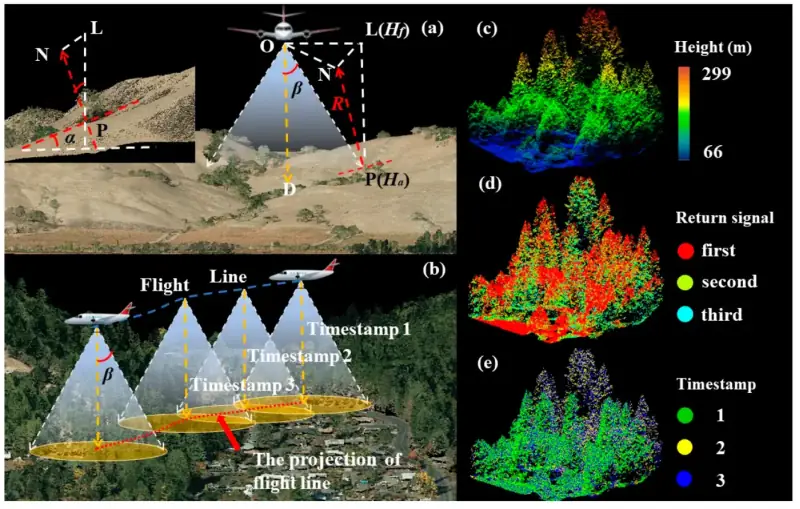
Remote sensing is the science of obtaining information about the Earth’s surface without being physically present. Lasers have become a critical tool in remote sensing applications, allowing researchers to capture detailed data about the environment. LIDAR (Light Detection and Ranging) is a common remote sensing technique that uses lasers to measure distances and create 3D maps of the environment. By emitting laser pulses and measuring the time it takes for them to return, LIDAR can create a detailed map of the terrain.
Topography mapping is one of the most common applications of LIDAR, allowing researchers to create detailed maps of the Earth’s surface. Vegetation monitoring is another important application of LIDAR, allowing researchers to measure the height and density of forests and other vegetation. Oceanography and marine life observation also benefit from LIDAR, as researchers can use lasers to measure the depth and properties of the ocean and observe marine life.
Laser Atmospheric Studies Applications
Atmospheric studies use lasers to measure atmospheric properties and gain insight into the composition and behavior of the atmosphere. Air pollution detection and monitoring is a crucial application of atmospheric studies, allowing researchers to measure levels of pollutants such as carbon monoxide, nitrogen dioxide, and sulfur dioxide. Greenhouse gas monitoring is another important application, enabling scientists to measure the levels of carbon dioxide and other greenhouse gases in the atmosphere.
Cloud and aerosol characterization is another important application of atmospheric studies. By using lasers to measure the size and composition of clouds and aerosols, researchers can better understand their impact on climate and weather patterns. Wind and turbulence measurement is also a key application of atmospheric studies, allowing researchers to better understand how air moves and how it affects our environment.
Advanced Laser Technologies for Remote Sensing and Atmospheric Studies
Advanced laser technologies are pushing the boundaries of remote sensing and atmospheric studies. Coherent Doppler LIDAR, for example, is a powerful technique that allows researchers to measure wind speeds and directions at high resolution. Differential Absorption LIDAR (DIAL) is another advanced laser technology that enables researchers to detect and measure trace gases such as ozone and methane.
Raman LIDAR is a technique that uses lasers to measure the spectral signature of molecules in the atmosphere, allowing researchers to identify and measure different atmospheric components. Dual-Polarization Doppler LIDAR is another advanced technology that uses lasers to measure the size and shape of particles in the atmosphere, allowing for more accurate measurements of cloud and aerosol properties.
Future Directions and Challenges
Despite the many benefits of laser technology in remote sensing and atmospheric studies, there are still many challenges to overcome. One of the biggest challenges is improving the accuracy and precision of laser measurements. Another challenge is improving the reliability and durability of laser systems, which are often sensitive and expensive.
However, there are also many opportunities for future research in this area. Advances in laser technology, such as the development of more powerful and efficient laser systems, could significantly improve the accuracy and precision of measurements. New applications of laser technology, such as the use of LIDAR in autonomous vehicles, could also open up new avenues of research.
Conclusion
Laser technology has become an essential tool for remote sensing and atmospheric studies, allowing researchers to gather precise and accurate data on our environment. From topography mapping to air pollution detection, lasers have a wide range of applications that make them invaluable to scientists. Advanced laser